
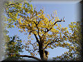
Position of Vlkov nad Lužnicí


For GPS users, it is enough to say latitude 49° 9' 3.6" N and longitude 14° 43' 30.4" E, but for the majority of visitors, it will be more friendly to say: Middle Europe, the Czech Republic, the South Bohemian Region in the Třeboň basin on the river Lužnice. From far and near, the highest "hill", Petrák (about 15 meters high), can be seen directly after you get off the train. It is no surprise that the majority of residents and tourists convey themselves by bike.
Try out our Photo Navigator or use the embedded Route Planner from Google Maps.
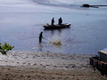
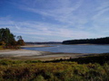
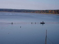
On the map, you will see that Vlkov is encircled from the North by 5 sand pits, which were created in the years 1956 – 1986 by sand mining on the both sides of river Lužnice. Thanks to the filtration of water from the Lužnice through the sand filters, beautiful lakes with the clear water were created, which invite you to swim. Everywhere from the South and East, you will meet pine forests and ponds. In Vlkov the tourist trail starts (for both bikers and walkers) which meanders around ponds with poetic names like: Countryside, Hope, Love, Trust, Goodwill, or Potěšil (Fountain of Happiness). On this trail, you can continue until you reach the largest Czech pond, Rožmberk (size 720 hectares), having seen thirty-six ponds before you finish. Due to the flat landscape, this area makes sports activities easy and safe for families with small children and for anyone with physical restrictions.


The Property for Recreants

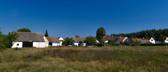
From the first view, the village is mostly isolated from civilization and the calm and peaceful pleasure of being protected from the world, and the fact that the parents could let be their children run or bike without restraint (because all the roads are blind), more than compensates for these handicaps.
Vlkov has its own pub, the great florist shop of Mr. Láf, and the public library. Basic shopping, restaurants, and services (such as for bikers and fishermen) are available in the town Veselí nad Lužnicí, 5 km from Vlkov. It is only 15 minutes away by bike. In Veselí, you can get a fishing pass for the 5 lakes and the rivers Lužnice and Nežárka. This table of distances shows that you can go anywhere quickly.
![[up]](/images/up.gif)
Nature and History
The region Třeboňsko has been for centuries covered by mankind,but thanks to their sensitivity toward nature, it is possible to declare Třeboň field a protected landscape area. Man has taken a part in the process of recreating the landscape since the 12. century, mostly by changing the water ratios of the original sprawling peat fields. The goal was to create a clever network of artificial canals (e.g. Zlatá stoka, Nová řeka) and the huge number of ponds which have been the vaunt of the Czech fishing industry until now. There are 460 ponds in total. This extensive pond system has become an important rookery and migration stop for water birds, and the area is well-known for its rich swamp and water vegetation. This region is important for the protection of many endangered vertebrates, such as the river otter and the sea eagle.
The most valuable jewel of nature in Třeboňsko is the extention of the original sprawling peat fields by the vegetable preservation corporations. Due to government restrictions on rerouting of the rivers, most of the original peat fields are saved by the periodic flooding of the gentlywinding streams of Lužnice and Nežárka. These periodically flooded wolds and swamp forests, together with the boney-dry windblown sands, are two regions of international importance, protected by the Ramsarská convention (focused on the Třeboňské fish ponds and Třeboň sprawling peat fields).

Directly within Vlkov is a real desert with renown sand dunes (dimension of 1 hectare). This unique natural phenomenon - Písečný přesyp - was declared a nature reservation in 1954. Besides the sand dunes, there are many distinct animals and especially herbs. The sand dunes arose long ago, after the Ice Age, when the sand from the surrounding river Lužnice became windblown.
In August 2002, this area suffered from floods which have no comparison. But nature and people returned to live within one year. Many photographs document the drama of the floods.


The richness of nature is appropriately joined witha long cultural heritage, and this, with a developed infrastructure, makes this place perfect for tourism. The landscape in Třeboňsko is complemented by rare settlements and the well-preserved unique architecture of historical towns and villages.
The village of Vlkov, with the court of Dehetník, was created together with village Hamr and Val in 13th century, when it was one complex. Vlkov was separated in the age of Marie Teresie (18th century). The village has now 150 inhabitants and their own municipality. Springing from their peaceful nature, the locals generously open their hearts to welcome the many visitors this area attracts throughout the year.
Copyright © 2007 – 2024 NTsoft & JHŠ Tábor , Last Updated - 09/23/2020
With very many thanks to Anne Weston for her invaluable help with translation.